
Use of Artificial Intelligence for Disaster and Risk Management
Risk management

Climate change is no more a myth. In the last couple of decades, climate change and the risks involved with it have amplified exponentially. These changes have increased the risk of natural disasters that wreak havoc on human life, property and the environment. There have been high-level debates on using science and technology to limit these mishaps, but their conclusions have been of little or no avail. One such technology that promises hope in natural disaster management is artificial intelligence (AI) technology.
Artificial intelligence technology makes the use of advanced machines that perceive their environment and take actions that maximize the chances of achieving the goal, similar to a human. These machines use training data and work on three cognitive skills that are learning, reasoning and self-correction. The learning part focuses on rules that convert the acquired data into actionable information, the reasoning part involves choosing the appropriate algorithm to reach the goal, while the self-correction helps the machine improve by analysing the previous errors and obstacles. AI carries the potential to understand the natural hazards, analyse the risk with the large volume of data fed to them and take proactive decisions for disaster risk reduction. It can stress-test various scenarios and understand the factors responsible for the risk, rather than just anticipating hazardous events.
World Meteorological Organization Information systems stated that AI can interpret the provided data and guide forecasters to predict with an informed decision. Disasters tend to warn before their actual occurrence. There are unusual signs in nature about a disaster that, if studied deeply, can help to predict their actual occurrence. It can be done effectively by the use of artificial intelligence. It will also help to reduce the time to access the damage to deliver the help aid quicker. For example, if the meteorological department predicts the occurrence of a cyclone or hurricane, the previous disaster data can be useful to estimate the effort and aid needed to recover from the forthcoming danger, based on the predicted severity of the occurrence.
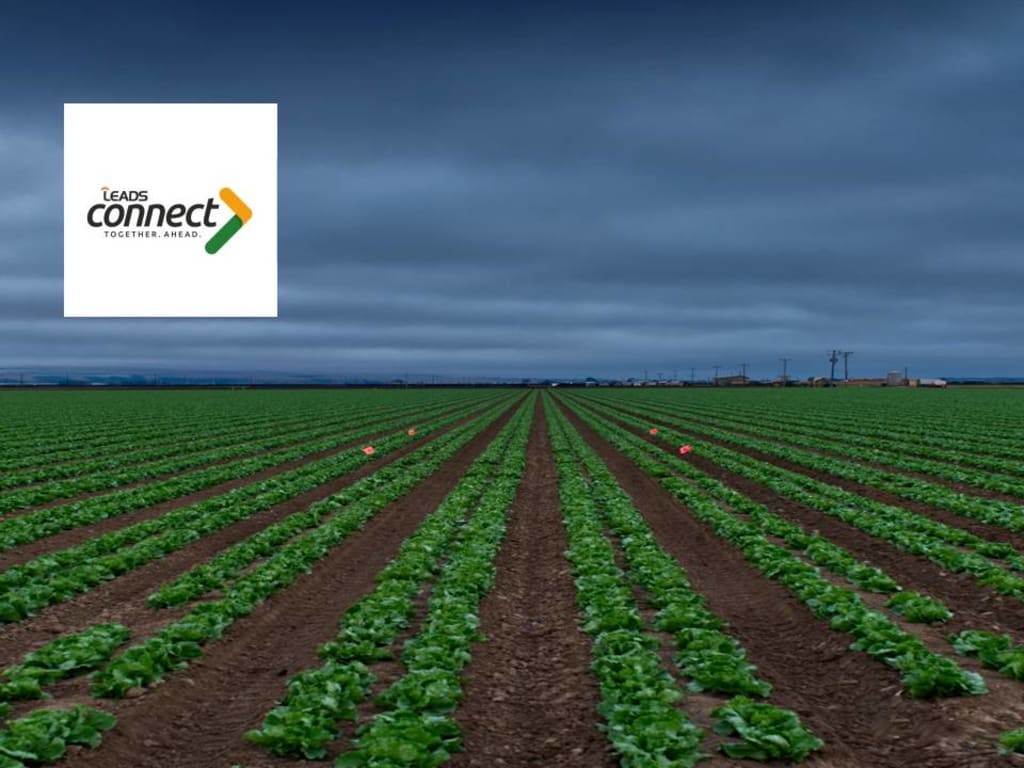
AI has increasingly been used in the agriculture sector too. The use of AI technology has enhanced crop production and improved the real-time monitoring, harvesting and processing of crops. These automated systems have helped with risk management in agriculture. It is used to detect parameters like weed detection, crop quality, yield detection and many other factors responsible for smooth crop production. Automated irrigation, weeding and spraying to enhance productivity can reduce human efforts and help farmers in particular. The use of AI to assemble a large amount of data from various websites, analyse them, and provide solutions to ambiguous issues is a smart way of irrigation that leads to a higher yield for the farmers.
For earthquakes, these AI machines can be trained with the help of previous seismic data to analyse the pattern of the earthquake occurrence, their magnitude, the location and the intensity with which they can cause destruction. For floods, AI can use previous rainfall records that had led to the disaster and flood simulations to monitor it. Volcanic eruptions, although rare, can be disastrous at times. Training AI machines to recognize the shape of ash particles and identifying the type of volcano can help in predicting eruptions and planning for volcanic hazard mitigation. By using seismic sensors and geological data, the location and intensity of future eruptions can be predicted.
Geographic information system(GIS) is another technique that promises to reduce the risk of these natural hazards. The role of GIS in disaster management can be revolutionary. GIS is a system that provides the ability to capture and analyse spatial and geographical data. GIS coupled with remote sensing technology provides a framework that helps in all stages of disaster management, from preparedness to response and recovery. The coordination of the response efforts and the planning for risk reduction can be enhanced using GIS decision support systems. GIS applications in disaster management include the use of satellite images, preparation of the base map, identification of safe zones for rehabilitation, evacuation planning and operation, suitable location-identifying scientifically for construction of houses and shelters, hospital and medical facility spots identification for injured people.
About the Creator
Leads Connect
LeadsConnect is an analytics company with core focus on Agri-technology driven Data Analysis and Modelling, and Risk Management & Financial Services.
Keep reading
More stories from writers in Futurism and other communities.
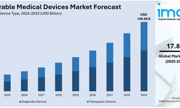
Wearable Medical Devices Market Trends: Remote Patient Monitoring, AI Integration & Forecast to 2033
Rising prevalence of chronic diseases, accelerating shift toward remote patient monitoring and telehealth services, and rapid advances in sensor technology, wireless connectivity, and AI-driven analytics are driving explosive growth in wearable medical devices, supported by expanded reimbursement policies and increasing consumer health awareness. According to IMARC Group's latest data, the global wearable medical devices market size was valued at USD 33.58 Billion in 2024. Looking forward, IMARC Group estimates the market to reach USD 149.08 Billion by 2033.
By Andrew Sullivana day ago in Futurism
Global Seeds Market Analysis: Crop Diversification, Precision Agriculture & Forecast to 2034
The world's farms are facing a fundamental challenge: feeding more than 9 billion people by 2050 while dealing with climate uncertainty, shrinking arable land, and a growing appetite for sustainable solutions. Seeds sit at the very heart of this equation. According to IMARC Group's latest data, the global seeds market was valued at USD 46.7 Billion in 2025. Looking forward, IMARC Group estimates the market will reach USD 53.2 Billion by 2034.
By Andrew Sullivan5 days ago in Futurism
Rachel Reviews: Lunch Tales: Teagan by Lucille Guarino
Well, I did enjoy this! Sometimes, all you need is just great storytelling and this is what Lucille Guarino delivers here. There's no big message to this book; it's just about folks and families, living their lives and coping with everything that's being thrown at them and finding their way. But when it's done well, like it is here, then you have characters to whom you can relate, tension which leaves you rooting for a better outcome, attraction which has your heart racing and an urge, as a reader, to see the characters happy with the people with whom they belong.
By Rachel Deeming4 days ago in BookClub


Comments
There are no comments for this story
Be the first to respond and start the conversation.