
Space exploration’s View of Earth
Space exploration has dramatically transformed our understanding of Earth. From the first satellite images to breathtaking views from the Moon and beyond, looking back at our planet from space has not only advanced science but also reshaped humanity’s perception of itself.

The ability to observe Earth from the vastness of space has provided insights into its climate, geography, and vulnerability, fostering a deeper appreciation for its fragility and interconnectedness.
(I)The First Views from Space
The first images of Earth from space came from suborbital and orbital missions in the mid-20th century. In 1946, a V-2 rocket launched by the United States captured the first grainy black-and-white photograph of Earth from an altitude of about 105 kilometers. This marked the beginning of an era where space technology could be used to study our planet from an unprecedented vantage point.
With the launch of the Soviet Union’s Sputnik 1 in 1957, artificial satellites became a primary tool for observing Earth. However, it was the Explorer 6 satellite in 1959 that provided one of the first significant images of Earth from orbit. As the Space Age progressed, images taken by TIROS-1, the first weather satellite launched in 1960, laid the foundation for modern meteorology.
(II)The Iconic “Blue Marble” and “Earthrise”
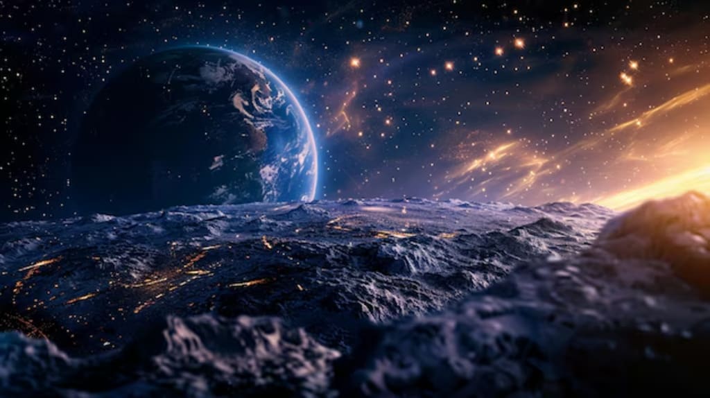
Perhaps the most profound moment in humanity’s visual connection to Earth came with the Apollo program. In 1968, the Apollo 8 mission produced the famous “Earthrise” photograph, taken by astronaut William Anders. This image showed Earth rising above the Moon’s horizon, symbolizing our planet as a small, fragile sphere floating in the vastness of space. The image profoundly influenced public consciousness, helping to inspire the environmental movement.
Even more striking was the “Blue Marble” photograph, taken by the crew of Apollo 17 in 1972. This full-disk image of Earth, bathed in sunlight, became one of the most reproduced images in history. It showed Earth as a unified, borderless world, reinforcing the notion that national boundaries are insignificant when viewed from space. The Blue Marble reinforced the idea of Earth as a single, interconnected system, influencing global perspectives on conservation and sustainability.
(III)Earth Observing Satellites and Climate Studies
Since the Apollo era, satellite technology has advanced significantly, allowing for continuous and detailed observation of Earth. Satellites such as Landsat, first launched in 1972, have provided invaluable data on deforestation, urbanization, and land use changes over decades.
NASA’s Earth Observing System (EOS), initiated in the 1990s, revolutionized how we study the planet. Satellites like Terra, Aqua, and Suomi NPP have contributed to understanding climate change, ocean currents, and atmospheric composition. The ability to monitor global temperatures, greenhouse gas levels, and ice sheet dynamics has been crucial in shaping climate policies worldwide.
The International Space Station (ISS) has also played a vital role in studying Earth. Astronauts aboard the ISS regularly capture images of natural disasters, urban expansion, and environmental changes, providing real-time insights that aid in disaster response and scientific research.
(IV)A Fragile Planet in the Cosmos
Space exploration has reinforced the idea that Earth is not an infinite resource but a delicate oasis in an otherwise inhospitable universe. The Overview Effect, a psychological shift experienced by many astronauts, describes the profound sense of unity and responsibility they feel when viewing Earth from space. Many astronauts have spoken about how seeing the planet without borders, conflicts, or divisions fosters a deep desire to protect it.
One of the most pressing concerns revealed by space-based observations is the impact of human activity on the environment. Satellite images have shown the alarming retreat of glaciers, deforestation in the Amazon, rising sea levels, and increasing pollution. Missions like the Copernicus Sentinel-5P satellite have provided data on air quality, monitoring pollutants like nitrogen dioxide and carbon monoxide on a global scale.
(V)Future of Earth Observation from Space
With advancements in artificial intelligence, big data, and miniaturized satellite technology, the future of Earth observation is promising. CubeSats, small and cost-effective satellites, are revolutionizing how data is collected and shared. Companies are Planet Labs operate fleets of CubeSats that provide daily high-resolution images of Earth, aiding in applications from agriculture to disaster response.
NASA and private entities like SpaceX and Blue Origin are also developing new space-based Earth observation tools. Future missions will focus on enhanced climate monitoring, more detailed weather forecasting, and studying the long-term effects of global warming. Additionally, projects seem the James Webb Space Telescope (JWST) and proposed lunar and Martian bases will allow for even more distant perspectives on Earth, enriching our understanding of its uniqueness.
IN THE END
The view of Earth from space has been one of the most transformative aspects of space exploration. From the first blurry images to today’s high-resolution satellite data, looking back at our planet has provided unparalleled insights into its beauty, complexity, and vulnerability. These perspectives have not only advanced science but also inspired a global movement toward environmental awareness and sustainability. As space technology continues to evolve, our understanding of Earth will deepen, reinforcing the need to protect and cherish the only home we have in the vastness of the cosmos.
About the Creator
Badhan Sen
Myself Badhan, I am a professional writer.I like to share some stories with my friends.
Keep reading
More stories from Badhan Sen and writers in Earth and other communities.
Wildfires: Causes and management
Wildfires are a natural part of many ecosystems but have become more frequent and severe due to human activities and climate change. While wildfires can play a role in renewing ecosystems, they also pose significant threats to human life, biodiversity, and air quality. Understanding the causes of wildfires and implementing effective management strategies are crucial for mitigating their impact.
By Badhan Senabout a year ago in Earth
The Geology of Your Inner World
We've journeyed through the solid crust, the molten mantle, and the expansive atmosphere of our Niche Earth. Now, it's time to explore the element that covers most of our planet and profoundly shapes its landscape: the Hydrosphere. For an overthinking girl, the hydrosphere is our emotional world – the vast, deep, sometimes turbulent, and often beautiful realm of our feelings.
By Being Inquisitiveabout 15 hours ago in Earth


Comments (2)
This is a very interesting article, and I remember seeing these photographs in many ways from textbooks to tv programs. Good work.
Nice work